A little montage of hiking some of the East Fork, Chattooga River, Ellicott Rock and Foothills trails in the Ellicott Rock wilderness area at the tri point of Georgia, South Carolina and North Carolina with my dog, Marvel.
Marvel is a dog. Like most dogs, she likes a walk. I am not a dog, but I have also been known to enjoy a walk. Since we got Marvel I’ve tried to take her on a longer walk semi-regularly.
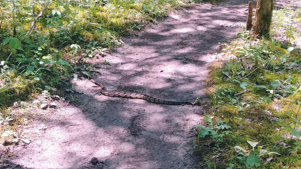
When we lived in Tennessee we used to walk the roughly five mile Hidden Springs Trail at Cedars of Lebanon State Park. One day we were about four miles in when we came across a rattlesnake lying in our path. We tried reasoning with him but after some negotiation we agreed to backtrack and thus completed eight miles of our five mile route.
It was good to know that Marvel is capable of much longer distances than I had previously considered. A few weeks after that encounter we ended up moving to Georgia. We jumped at this and about once a month or so we’d head up into the mountains and take a walk.
In March of this year we drove up into the foothills of South Carolina to Walhalla Fish Hatchery, leaving the apartment at 3.30 am. We arrived at the trailhead at sunrise. It was actually a little before sunrise as we were so low in a steep valley, which explained the difficulty I had finding the trailhead in the dark.
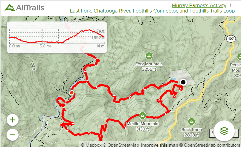
Our plan – I say ours, Marvel didn’t really get much of a say – was to head down the banks of the East Fork of the Chattooga River to where it meets the Chattooga River itself. The loop trail would then head south, but we would sneak north up to the point where North Carolina, South Carolina and Georgia meet and see if we could find Ellicott’s Rock, a survey marker from 1811 indicating where the border between Georgia and North Carolina lay. It is off by about 230 feet.
We would then backtrack, following the river south to a connector trail that would take us up to the Foothills Trail, which we would follow back to Fish Hatchery road. A quick hop down Fish Hatchery road would take us back to where we parked.
Within a couple of miles I realized I was somewhere special. This was one of the most beautiful places I had ever been and an atmosphere that just brought me peace. I usually took a couple photos of Marvel hiking for the Facebook likes, but this time I started taking short video clips of about five to ten seconds. Like, a lot of them. Like, close to sixty of them.
So, anyway, we hiked. We made it to the main fork and hung a right. We made it to the state line and we ate lunch in North Carolina. There’s a great blog post with photos explaining exactly how to find the Rocks at dwhike. Unfortunately since that was written the trees he used to identify where to look blew down in a storm and we failed to locate it.
We followed the river south, crossing the East Fork. After a few miles we stopped at a beautiful sandy river beach where Marvel had fun chasing rocks into the river and I got my requisite hike photo for Facebook where I can pretend she can be peaceful.

The climb out of the valley on the Foothill trails was brutal. The initial climb goes up 1000 ft in under 3 miles and has an average grade of 7% over that 3 miles. The views were great though and gave me some of the only cellphone signal I had all day. It’s great to not get any notifications – one of the main reasons I hike is because I can’t check my work e-mail if there’s no phone signal – but I do need spots with access so I can post the picture to Facebook and let people know I’m cool.
The only bad part of this hike was the hike down Fish Hatchery Road. It’s a mile and a half of asphalt at a 4% grade. At least it’s downhill but it’s somewhat demoralizing. You feel like the hike is over and you should be in the car headed home, but you still need to walk more than a mile in sore feet. If doing this loop and you have the ability I think it would be much nicer if you could leave a bicycle at the top of the hill then park at the bottom so you could freewheel down at the end.
We did 13.6 miles in five and a half hours, climbing a total of 1,600 feet. After getting home I quickly threw together the little clips from my phone using Google Photos video editor. It’s not fancy or powerful or at all fit for this purpose, but it sure is easy.

One response to “Ellicott Rock Wilderness Area Hike”
[…] our adventure in the Ellicott Rock Wilderness Area I wanted to do more of that, but better. Filming Marvel on my cellphone and throwing a quick video […]
LikeLike